The flight path of the jetliner in the animation was produced by applying the tube module to a polyline geometry produced by the read geom module. The animation of the tube was performed by a simple program which takes as its input a time dependent cubic spline. The program evaluates the spline at specified points to create a polyline geometry for read geom. Each new point added to the polyline causes a new segment of the flight path to be generated. Four separate tube modules were employed to allow the flight path segments to be colored green, red, yellow, and green during the engine failure and restart sequence.
The path of the jetliner is based on flight recorder data obtained from the Federal Aviation Administration. The flight path was modeled using three dimensional time dependent cubic splines. The technique for deriving and manipulating the spline functions is so powerful that we created a new module called the Spline Animator for this purpose. The details of this module are described in [1]. A similar technique is used to control the camera motion required for the flyby in the video animation.
By combining the jetliner flight path with the animation of the ash plume described earlier, a simulated encounter of the jet with the ash cloud can be studied in an animated sequence. The resulting simulation provides valuable information about the accuracy of the plume model. Because ash plumes are invisible to radar and may be hidden from satellites by weather clouds, it is often very difficult to determine the exact position and extent of an ash cloud from direct observations. However, when a jetliner penetrates an ash cloud, the effects are immediate and unmistakable and the aircraft position is usually known rather accurately. This was the case during the December 15 encounter.
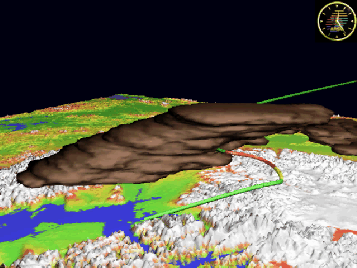
Figure 7: Flight path of jetliner through ash cloud.
By comparing the intersection point of the jetliner flight path with the plume model to the point of intersection with the actual plume, one can determine if the leading edge of the plume model is in the correct position. Both the plume model and the flight path must be correctly co-registered to the terrain data in order to perform such a test. Using standard transformations between latitude-longitude and x-y coordinates for the terrain, we calculated the appropriate coordinate transformations for the plume model and jet flight path. The first time the animation was run we were quite amazed to observe the flight path turn red, denoting engine failure, at precisely the point where the flight path encountered the leading edge of the modeled plume. Apparently this was one of those rare times when we got everything right. The fact that the aircraft position is well known at all times, and that it encounters the ash cloud at the correct time and place lends strong support for the correctness of the model. Figure 7 shows a frame from the video animation at the time when the jetliner landed in Anchorage. The ash cloud in this image is drifting from left to right and away from the viewer.