Ash clouds can often be detected in AVHRR satellite images. For the December 15 events, only one image recorded at 1:27pm AST was available. At the time of this image most of the study area was blanketed by clouds. Nevertheless, certain atmospheric features become visible when the image is subjected to enhancement, as shown in Figure 8. A north-south frontal system is moving northeasterly from the left side of the image. To the left of the front, the sky is generally clear and surface features are visible. To the right of the front, the sky is completely overcast and no surface features are visible. One prominent cloud feature is a mountain wave created by Mount McKinley. This shows up as a long plume moving in a north-northeasterly direction from Mount McKinley and is consistent with upper altitude winds on this date.
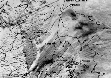
Figure 8: AVHRR image taken at 1:27pm.
The satellite image was enhanced in a manner which causes ash clouds to appear black. There is clearly a dark plume extending from Mount Redoubt near the lower edge of the image to the northeast and ending in the vicinity of Anchorage. The size of this plume indicates that it is less than an hour old. Thus, it could not be the source of the plume which the jet encountered approximately 2 hours before this image was taken.
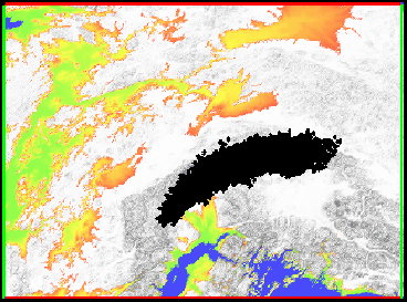
Figure 9: Simulated ash cloud at 1:30pm.
There are additional black areas in the upper right quadrant of the image which are believed to have originated with the 10:15am eruption. These are the clouds which the jet is believed to have penetrated approximately 2 hours before this image was taken. The image has been annotated with the jetliner flight path entering in the top center of the image and proceeding from top to bottom in the center of the image. The ash cloud encounter occurred at the point where the flight path reverses course to the north and east. However, the satellite image does not show any ash clouds remaining in the vicinity of the flight path by the time of this image.
When the satellite image is compared with the plume model for the same time period, shown at approximately the same scale in Figure 9, a difference in the size of the ash cloud is readily apparent. While the leading edge of the simulated plume stretching to the northeast is located in approximately the same position as the dark clouds in the satellite image, the cloud from the simulated plume is much longer. The length of the simulated plume is controlled by the duration of the eruption, which was 40 minutes.
Two explanations for the differences have been proposed. The first is that the length of the eruption was determined from seismic data. Seismicity does not necessarily imply the emission of ash and therefore the actual ash emission time may have been less than 40 minutes. The second possibility is that the trailing end of the ash cloud may be invisible in the satellite image due to cloud cover. It is worth noting that the ash cloud signatures in this satellite image are extremely weak compared to cloudless images. In studies of the few other eruptions where clear images were available, the ash clouds are unmistakable in the satellite image and the model showed excellent agreement with the satellite data.