The geographical region for this visualization study is an area in
southcentral Alaska which lies between 141 ![]() - 160
- 160 ![]() west
longitude and 60
west
longitude and 60 ![]() - 67
- 67 ![]() north latitude.
The corners of the region define a
Cartesian coordinate system and the extents of the volcano plume data
must be adjusted to obtain the correct registration of the plume data in
relation to the terrain.
north latitude.
The corners of the region define a
Cartesian coordinate system and the extents of the volcano plume data
must be adjusted to obtain the correct registration of the plume data in
relation to the terrain.
The terrain features are based on topographic data obtained from the US Geological Survey with a grid spacing of approximately 90 meters. This grid was much too large to process at the original resolution and was downsized to a 1426x1051 element array of terrain elevations, which corresponds to a grid size of approximately 1/2 mile. As shown in Figure 5, the terrain data were read in AVS field data format and were converted to a geometry using the field to mesh module.
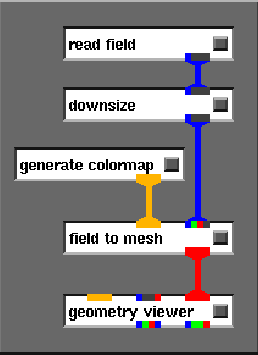
Figure 5: AVS terrain network.
We also included a downsize module ahead of field to mesh because even the 1426x1051 terrain exceeded available memory on all but our largest machines. For prototyping and animation design, we typically downsized by factors of 2 to 4 in order to speed up the terrain rendering.
The colors of the terrain are set in the generate colormap module according to elevation of the terrain and were chosen to approximate ground cover during the fall season in Alaska. The vertical scale of the terrain was exaggerated by a factor of 60 to better emphasize the topography.
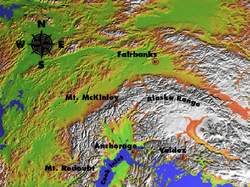
Figure 6: Terrain visualization of study area.
The resulting terrain is shown Figure 6 with labels that were added using image processing techniques. Features in the study area include Mount Redoubt, Mount McKinley, the Alaska Range, Cook Inlet and the cities of Anchorage, Fairbanks and Valdez.
To create the global zoom sequence in the introduction to the video animation, this image was used as a texture map that was overlaid onto a lower resolution terrain model for the entire state of Alaska. This technique also allowed the study area to be highlighted in such a way as to create a smooth transition into the animation sequence.