
A baseline is a distance between two satellites. Occasionally, the term "temporal baseline" is also used, which refers to the time interval between sucessive satellite observations. Normally, however, what we call a baseline is an actual distance, and is separated into two cartesian components or else expressed in polar form.
At ASF, we separate the baseline into two components, which can change (linearly) across an image. These are:
ASF's sign convention for the parallel baseline is opposite that of ESA; but our sign conventions agree for the normal baseline.
The baseline is used to interpret satellite phase as elevation.
During DEM generation, the baseline must be known very accurately (within a few centimeters); but the baseline is rarely known this well beforehand. Hence, we have to work backwards from known elevations to calculate the baseline. The tandem_ifm program refines the baseline in this way.
A small baseline results in a coherent interferogram
and few phase fringes for a given elevation:
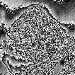
A large baseline results in a less-coherent
interferogram and more phase fringes for a given elevation.
Back to interferometry main page
Last Updated: September 1, 1998
If you have any questions, please feel free to email olawlor@acm.org