Alaska is situated on the northern boundary of the Pacific Rim. Home to the highest mountains in North America, the mountain ranges of Alaska contain over 40 active volcanoes, shown in red in Figure 1. In the past 200 years most of Alaska's volcanoes have erupted at least once. Alaska is a polar crossroads where aircraft traverse the great circle airways between Asia, Europe and North America, as shown in white in Figure 1. Volcanic eruptions in Alaska and the resulting airborne ash clouds pose a significant hazard to more than 40,000 transpolar flights each year.
The ash clouds created by volcanic eruptions are invisible to radar and are often concealed by weather clouds. This paper describes a system developed by the Alaska Volcano Observatory and the Arctic Region Supercomputing Center for predicting the movement of ash clouds. Using meteorological and geophysical data from volcanic eruptions, a supercomputer model provides predictions of ash cloud movements for up to 72 hours. The AVS visualization system is used to control the execution of the ash cloud model and to display the model output in three dimensional form showing the location of the ash cloud over a digital terrain model.
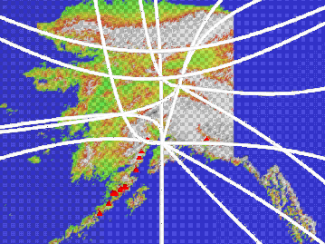
Figure 1: Active volcanoes and air routes in Alaska.
Eruptions of Mount Redoubt on the morning of December 15, 1989, sent ash particles more than 40,000 feet into the atmosphere. On the same day, a Boeing 747 passenger jet experienced complete engine failure when it penetrated the ash cloud. The ash cloud prediction system was used to simulate this eruption and to produce an animated flyby of Mount Redoubt during a 12 hour period of the December 15 eruptions including the encounter of the jetliner with the ash cloud. The animation combines the motion of the viewer with the time evolution of the ash cloud above a digital terrain model.
The visualization of the aircraft encounter with the ash cloud can be used to test the accuracy of the ash plume model. The aircraft position was known accurately in three dimensions at the time of the encounter and can be compared with the position of the ash cloud produced by the model. Satellite imagery is also used to assess the accuracy of the model by comparing the observed horizontal extent of the ash cloud with the visualization produced from the model data.