A DEM is a Digital Elevation Model-- an image consisting of heights above sea level for some location. It shows terrain-- mountains, valleys, plains.
DEMs can be used in many ways-- SAR terrain correction, hydrology, line-of-sight planning for radio towers, or even hiking.
In interferometry, these are often our end result.
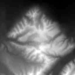 This DEM shows a small mountain range just south of Delta Junction, Alaska.
The data comes from the United States Geological Survey (USGS) GeoData
FTP Site and
WWW site.
This DEM shows a small mountain range just south of Delta Junction, Alaska.
The data comes from the United States Geological Survey (USGS) GeoData
FTP Site and
WWW site.
In this DEM, we've mapped 400m above sea level to black, and 1800m above sea level to white.
Back to interferometry main page
Last Updated: September 1, 1998
If you have any questions, please feel free to email olawlor@acm.org